Practical guide · Choosing 3D deliverables
Gaussian Splats, Point Clouds or Meshes? Choosing Deliverables for an Aerial Project
An aerial survey of a business park can support a visual tour, a site inspection or an interactive drive-through. Each task calls for different deliverables. Before processing the imagery, establish who will use the result, which software will open it and what they need to do.
Start with the task
Gaussian scenes render appearance from different viewpoints; point clouds retain spatial samples; meshes describe surfaces with connected faces. Use the table to choose a starting point, then follow the checks for that task.
| Start with | Your task | Before delivery |
|---|---|---|
| Gaussian scene | Visual tours, leasing presentations and walkthrough imagery. | Coverage along the route, close-up appearance and performance on the target device. |
| Point cloud | Inspecting spatial samples, registration, sections and validated measurements. | Coordinates and units, coverage and noise, independent checkpoint errors. |
| Mesh | Surface cleanup, material editing, collision and other geometry deliverables. | Holes and broken faces, normals and textures, actual use in the target software. |
| Gaussian scene + mesh | Combining scene appearance with vehicle or character interaction. | Alignment, collision boundaries, ramps and turns. |
For a visual tour, inspect the route through the Gaussian scene
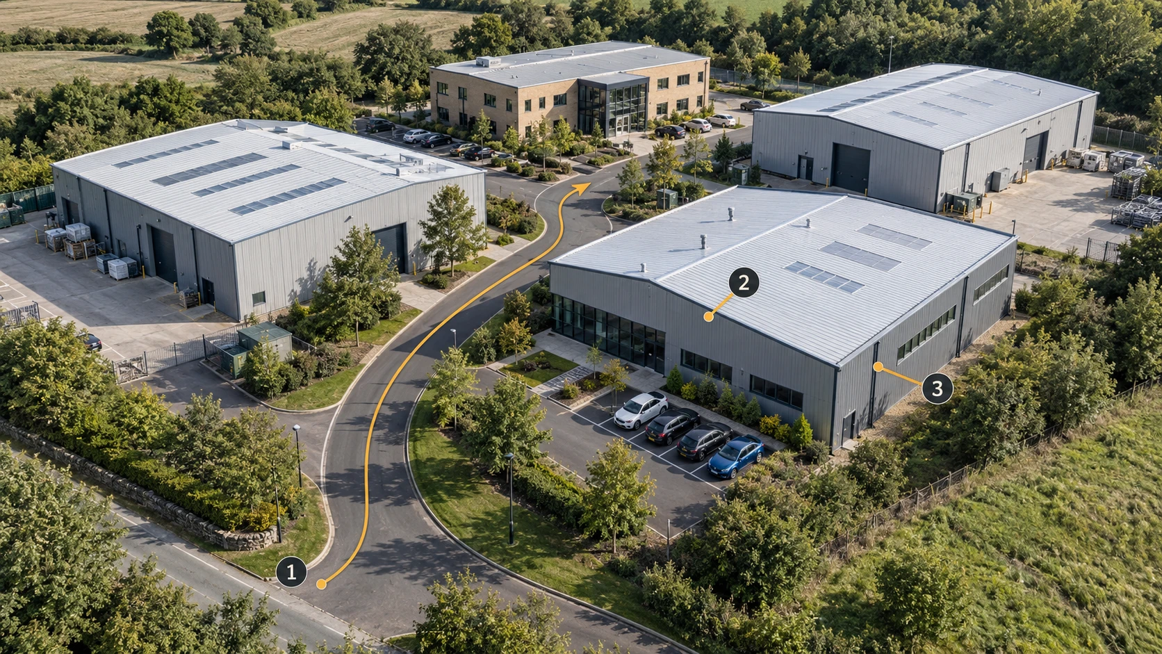
For a delivery focused on the park’s appearance, reconstruct the Gaussian scene in MakeWorlds Studio, then inspect it along the client’s intended route: an overview from the entrance, buildings along the road and a closer look at a key facility. That route becomes the working checklist for scene review.
Check the overview, then follow the road.
Follow the road marked 1 and inspect spaces between buildings, parking areas and corners. Note missing content, floaters or abrupt loss of detail for follow-up.
Pause at roofs and facades.
Inspect the roof edge at 2, then lower the viewpoint to inspect windows, walls and eaves at 3. If the imagery only covers roofs, add oblique or lower viewpoints that reveal the facades before planning a near-ground tour.
Repeat the route on the receiving device.
Use a Gaussian-capable viewer on the client’s actual device. Check initial loading, navigation smoothness and detail at key stops. If the device struggles, validate a smaller delivery area before expanding.
The agreed route opens correctly, remains navigable and shows the required detail. Prepare and validate suitable geometry separately when the project also needs measurements or collision.
For site inspection, check point-cloud coordinates and coverage
For road sections, alignment between captures or spatial inspection, agree on the required area, attributes and acceptable error before processing.
Confirm coordinates, units and attributes.
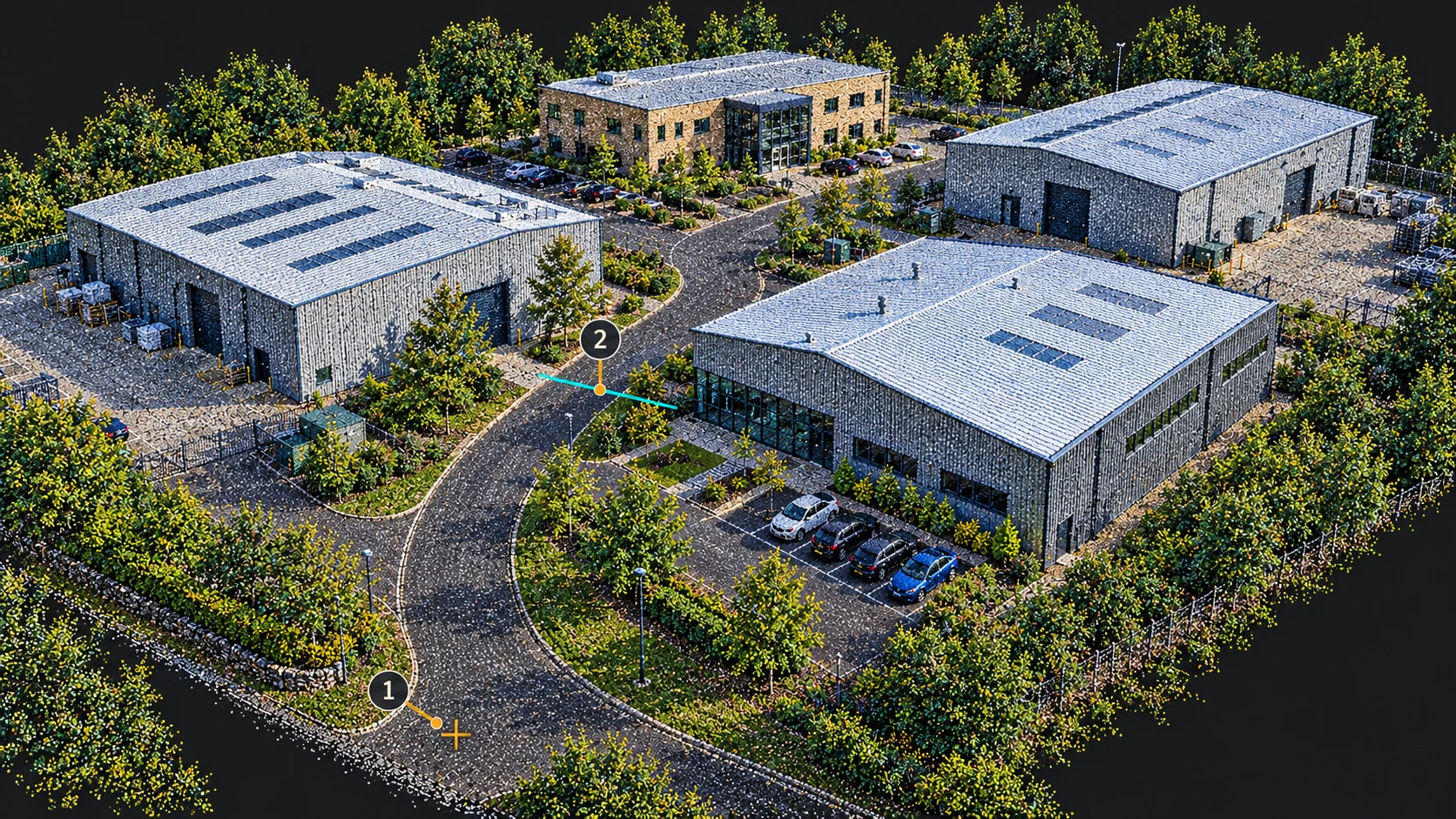
Confirm horizontal and vertical references, units, extent and any required color or classification attributes. Import a small sample and check known positions and dimensions for offsets, scale errors or mismatched height references.
Inspect ground, roofs and occluded edges.
Change viewpoints and inspect sections where needed. Look for road gaps, roof outliers and missing ground beneath trees. Collect additional observations for unseen ground; canopy points are not ground measurements.
Validate error at independent checkpoints.
Compare against independently surveyed checkpoints distributed across the project and not used to constrain the model. Record the method, errors and missing areas, then assess them against the agreed requirements. Visual density alone is not validation.
The recipient can position the data correctly, perform the agreed sections or analysis and understand its error and coverage. Treat unvalidated data as a visual reference until accuracy has been checked.
For editing and interaction, inspect the mesh surfaces
If the recipient needs to repair building shapes, edit materials or build a drive-through, start with a sample containing a road, a building and a ramp. Check the surfaces in the intended workflow.
Import a sample and check its placement and scale.
Open the file in the receiving software and check orientation, units and a known dimension. Resolve unexpected size or offsets through coordinate and import settings before editing.
Inspect wireframes, holes and textures.
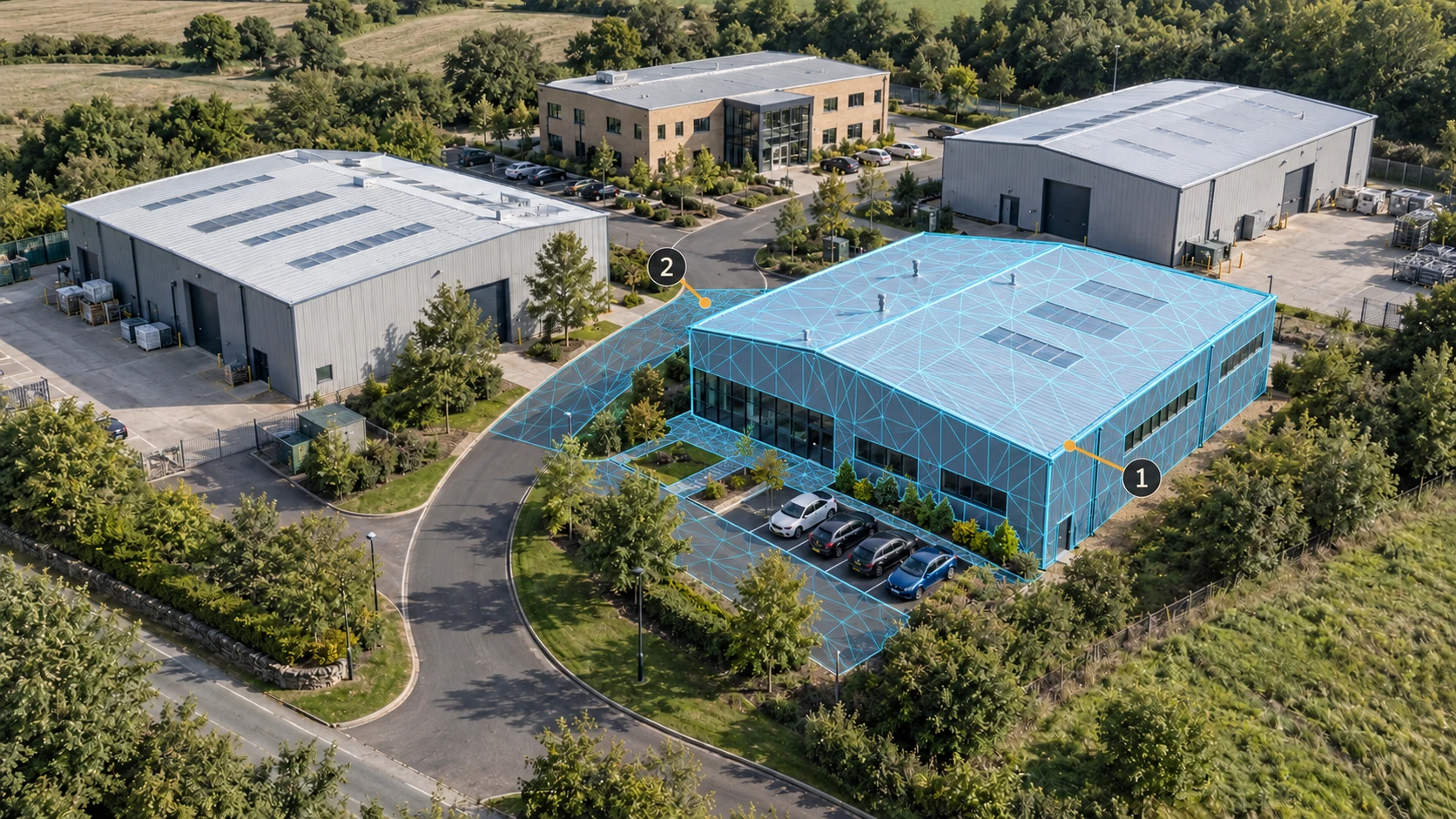
Inspect buildings and roads for holes under eaves, faces spanning real gaps, flipped normals and misaligned textures. Refer to the source photos when repairing surfaces, and decide whether unsupported areas need more capture.
Prepare for the task, then verify the export.
For interaction, check road continuity and configure collision supported by the target engine. For presentation, inspect silhouettes and textures after simplification. Reimport the export and verify materials, placement and required attributes.
The mesh works in the recipient’s editing or runtime workflow, without surface issues that prevent the agreed task. Validate geometric accuracy for the intended use; printing also needs checks for watertightness, wall thickness and print scale.
Combine appearance and collision for a drive-through
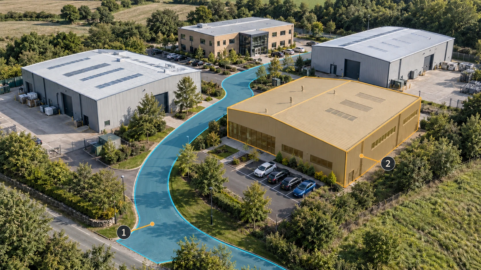
For a drive-through, review and refine the Gaussian scene’s appearance in MakeWorlds Studio, then pair it with simplified road, building and obstacle collision geometry in the target engine. Confirm support in the engine and importer first, and manage the appearance and collision assets separately.
Align both datasets against shared landmarks.
Check origin, units and orientation, then compare several separated landmarks such as intersections, building corners and ramp starts. One matching corner is not enough to establish alignment across the park.
Run the vehicle or character along the route.
Test straight sections, turns, ramps and building edges in the target engine. Look for ground penetration, floating or unexpected blocking. After changing collision, repeat the route and compare visible surfaces with traversable boundaries.
Validate a sample before processing the whole park
Choose an area with a facade, road, trees and an elevation change. Have the recipient import and use it in their actual software. Include these five items with the sample:
- Task and scope: the tour route, inspection locations or interactive area.
- Data type and format: Gaussian scene, point cloud or mesh, plus the receiving software and version.
- Coordinates and scale: units, reference system, orientation and a known dimension or landmark.
- Quality record: checked routes or areas, validation method, errors and remaining gaps.
- Supporting files: textures, required attributes, collision data and brief opening instructions.
For a Gaussian delivery, export a small Gaussian PLY sample from MakeWorlds Studio and have the recipient open it in their actual software and follow the agreed route. Validate that sample before expanding to the whole park. Point-cloud and mesh deliveries need their own workflow checks; a format conversion alone does not establish accuracy, surface quality or interaction readiness.